Historical Rockbridge Annotated Map

An annotated historical map published by the Roanoke Valley Historical Society showing Rockbridge County, Virginia, 1778-1865.
Borden Grant map

In 1739 Benjamin Borden, a New Jersey Quaker, received a grant beginning at the southern boundary of Beverley Manor. Borden was promised 1,000 acres for every settler he located, amounting in all to 92,000 acres. John McDowell, a surveyor, helped Borden locate his tract and was rewarded with a large acreage. The Borden tract later became Rockbridge County.
Rockbridge Map, 1860s

Map showing the location of many Rockbridge County, Virginia, land owners in 1860s.
Gilham Map, 1860

Map of Rockbridge County, Virginia from surveys made by William Gilham, Professor of Agriculture, Virginia Military Institute; assisted by cadets Lumsden … [et al.]; drawn by cadet W.N.P. Otey. The map includes the names and locations of mills, churches, iron furnaces, and primary land owners.
Gray’s Map of Lexington, 1877

Gray’s New Map of Lexington, Rockingham County, Virginia. Drawn from Special Surveys, 1877. Drawn, Engraved, and Published by O.W. Gray & Son, Geographers, Manufacturers of Maps and Atlases, 10 North Fifth Street, Philadelphia. Jacob Chace, Topographical Engineer, Manager of Local Surveys. Note: This map incorrectly places Lexington in Rockingham, rather than Rockbridge County, Virginia.
Carmichael Map, 1883

The county of Rockbridge, Virginia, prepared by John Carmichael. He has used as a basis the map of Col. William Gilham, VMI, 1859, and that of Maj. Jed Hotchkiss and railroad and private surveys. Information as to mineral development by Prof. John L. Campbell, of Washington and Lee University. December, 1883.
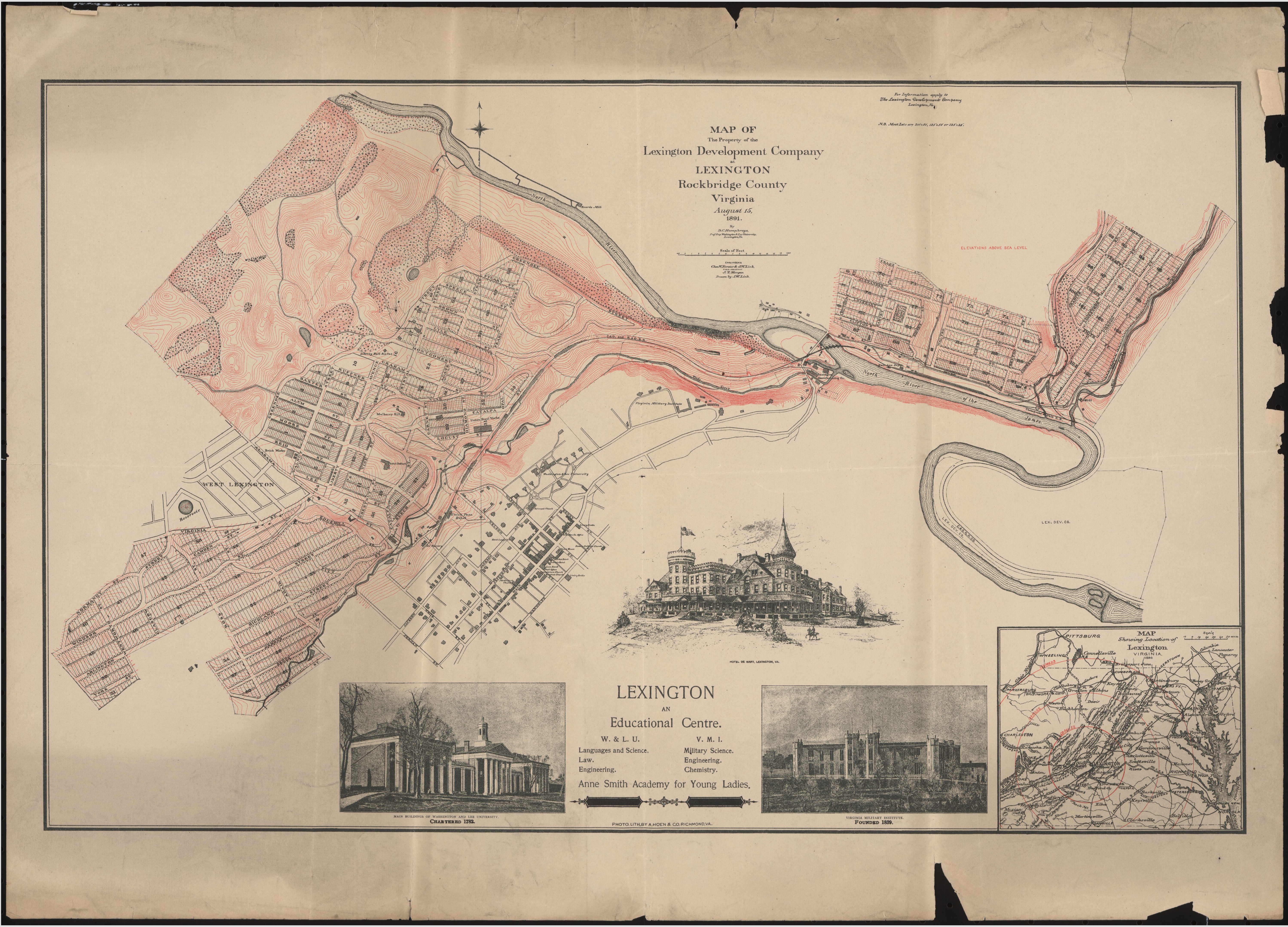
Lexington Development Company, 1891

Map of the Property of the Lexington Development Company at Lexington, Rockbridge County, Virginia August 15, 1891, by D.C. Humphreys, Prof. Eng. Washington & Lee University, Lexington, Va. ; Engineers Chas. W. Forster & J.W. Link ; Field Assistant J.T. Morgan ; drawn by J.W. Link. Relief shown by contour lines. Shows downtown Lexington, plus street names, numbered blocks and lots of the area owned by the Company. Note: The Lexington Development Company was part of the speculative real estate boom of the 1890’s. Few lots were sold and the new neighborhoods shown on this map were never built.
Buena Vista Panorama, 1891
